|
|
Practical
Informations
|
|
FORESTS and GLACIERS
|
|
Practical
Informations
|
|
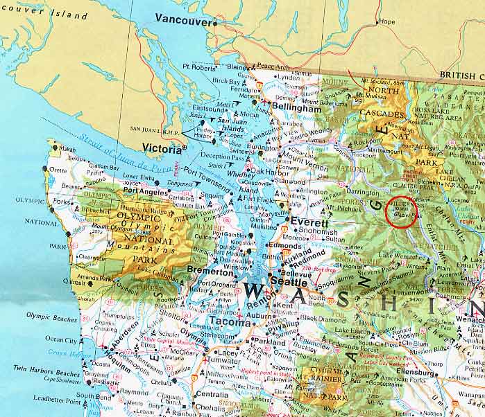
(Glacier Peak Wilderness - Cascade Range - NW USA - August 2004)
|
North West of the USA, at the very door of the city of Seattle, lies an area of volcanoes and forests, abundantly watered by the winds coming from the Pacific Ocean. National Parks have been created there : Olympic, Mount Rainier, as well as the most recent Park created in the US : North Cascades. Close to these Parks, Wilderness Areas have been set aside. In these zones, man's footprint remains practically invisible : hiking, hunting, fishing, are permitted, but permanent buildings and vehicles are prohibited. |
 |
The classification of a zone as a "Wilderness Area" is the world's highest level of Nature protection.
Rare trails have been cleared (shortcutting trail switchbacks is prohibited !). Cross-country hiking is not easy (if not plain impossible !), except in non-wooded areas. Very unobstrusive signs are sometimes posted, and the trails are maintained by rangers and volunteers. Some, like the Pacific Crest Trail (PCT) are well maintained, but many are left in natural conditions. Log bridges have been built on some trails, but one should inquire before going on a non-maintained trail, as fords are frequent, and may be difficult and dangerous.
Camping is permitted, but it is recommended to pitch the tent exclusively in wooded or moraine areas, at least 200 ft from a lakeshore. Sometimes, in more crowded areas, very primitive toilets have been set up. Campfires may be permitted, as a function of the risks of forest fires : in any case, one should bring a camp stove.
The result is that, aside from the trails (often very inconspicuous), human footprints are practically invisible : no building, and not even the smallest piece of trash...
And rangers check at regular intervals...
The climate :
This area is at the same latitude as the North of France, but it is subject to the rain-carrying winds of the Pacific Ocean. Above an altitude of 2000 meters, most precipitations come in as snow, hence the great number of glaciers, even at low altitudes.
During our stay, we were lucky and enjoyed
a particularly long period of dry weather, and high temperatures (which sometimes
turned the low altitude walks a bit arduous...)
Our intinerary :
Our final objective was to climb Glacier Peak, a less-frequented summit, because of its remoteness. Furthermore, heavy rains, at the end of 2003, have destroyed many bridges on the normal access trails, compeling to a long detour. Thus, in 2004, the mountain was particularly free of visitors (8 people had summited, until August 15...).
Wishing to get acquainted with the local conditions, and to perfect our training, we decided to start by a 5-days hike (Trinity - Buck Creek Pass - Miners Ridge - Lyman Lake - Phelps Creek) illustrated in pages 2 and 3.
Then we went to Glacier Peak, by ways of the Little Wanatchee Trail (be careful : this trail is not maintained, and is completely overgrown with bushes...) and the Pacific Crest Trail : one day to Indian Pass, one day to reach the foot of the mountain, through White Pass, and cross-country from there. We figured on 2 days to go up, one day to summit, and 2 days to get down. But we should have set up our tent higher, at Glacier Gap, at the foot of the N Ridge : we camped too far.
Documentation :
- The best maps are probably the Green
Trails Maps . They
are similar to our IGN maps, but their scale is 1/69500... (Easy : one just
has to take a calculator along...) We could verify that the 2002 map was not
fully up to date...
- If you are planning an ascent, the most detailed books are those in the "Cascade
Alpine Guide" collection,
written by Fred Beckey (The Mountaineers
- Seattle). Three volumes cover the area of the Cascade Range in the State
of Washington. These books are quite thick, and include a lot of informations,
aside from the route descriptions, drawings and photographs.
- There is also an excellent software, TOPO!,
that comes with digitized maps. But the whole area is not covered by the existing
maps. The software is very user-friendly and is an excellent tool to prepare
the itinerary, with even a possible link to a GPS.
- Visit the site of the USDA Forest Service,
to get the latest information of the trail conditions.
- Spend some time visiting the numerous web sites posting informations and trip
reports, like the Washington
Trail Association, or Trail NW. Google
is your friend !
- And if you still have unanswered questions, do as I did, and ask them on the
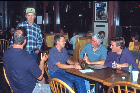
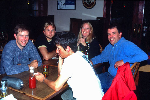
forum of NWHikers.net : the members of
the forum are extremely nice and will bend over backward to help you. We even
met about 20 of them in a pub, when we got back !
What to bring along :
- Full camping gear : there are no mountain
huts. During summer, the temperature does not go very low, even at altitude
(It could even be quite hot ! We experienced temperatures in the 80s°F -
over 30°C...), but one should always carry protection against rain, frequent
in those areas... We have been lucky, and the weather has been very nice most
of the time, to the point that we slept frequently in our bivi sacks. Our tent
was too light, and did not resist heavy rain. It seems that hikers frequently
use a tarpolin hung on trees.
- Food for the duration of the hike. Freeze-dried food is easily available locally,
in the REI stores, for instance. Jerky, a kind
of dried meat, very light and tasty, may be purchased in many food stores. I
love it !
- Water is no problem : streams are everywhere. But, of course, it should be
treated.
- Take a camp stove along. C206 Camping Gaz cartridges may be found easily,
but watch out : the cartridges we purchased at REI were filled with a mixture
of a butane-propane mix. This mix is much less efficient than pure butane :
almost 30 minutes to heat up a small water pan ! We have not seen any small
cartridges (C360). The local hikers mostly use white gas stoves.
- And, of course, one should be prepared to protect against rain...
Animals :
- We have not seen any
bear, but there are some. It seems that they are not very dangerous, as they
are not used to men. But don't leave any food in the tent, just in case... We
did suspend our food in a tree... but I wonder if this is effective ? One of
the hikers we saw used a special bag to hang his food from a tree, but the other
(rare) hikers we saw did not seem to take any special precaution.
- Watch out for the (very big) marmots : they must certainly love food too...
- At certain times, and in certain places, flies and mosquitoes seem to be a
real bother. We purchased locally (REI) products
to fend them off, but we saw very few. Maybe a question of time of the year
? It seems that they are more frequent early in the summer.
- On the morning between our two hikes, we figured we would rest and sleep late,
but we were bombarded by a squirel in the process of gathering his winter reserve
of pine cones.... Hence : consider bringing a hard hat ;))...
And, most important, don't forget that Wilderness Areas are very wild and remote : we met 10 to 15 people a day, at the most, in the busiest areas (on the Pacific Crest Trail). On some days, we saw absolutely nobody. If you have an accident, you may count only on yourself...
Finally, we would like to
thank again our new friends from NWHikers
:
without them, and their recommendations, we probably could not have made these
two fantastic hikes !
Thanks again !
We'll be back !
 |
 |
  |